Glacier’s Glaciers


A somewhat whimsical guide to the glaciers of Glacier National Park


Panorama of Grinnell, Gem and Salamander Glaciers. A top geologist in the park once told me that Salamander is her favorite glacier because when it melts it looks like it’s peeing.  Salamander is just left of the center of the photo about mid-way up the cliff.  And indeed … I’ll let you find the run-off falls coming off of it 😉

As part of my training to be a hiking guide in Glacier National Park, I was required to give a short presentation on a subject relating to what makes the park unique, its history, or a scientific subject relevant to the park. I was assigned the topic of Glacier’s Glaciers and enjoyed working on my presentation so much that I wanted to share it here for anyone else who might be interested! It’s also one of the most frequent subject matters I get asked about as a guide.
 
So without further ado, ladies and gentlemen, may I present to you… Glacier’s Glaciers.


What is a glacier?

The true definition of a glacier is a mass of ice so heavy that it flows under its own weight. Imagine pressing down on an ice cube on a flat table. As you added more and more weight to the ice, the pressure would eventually become so intense that the ice would slide out from under your hand, leaving a trail of water in its wake. A common threshold for determining if an ice mass might be big enough to flow under its own weight is if the ice covers an area of .1 km squared or about 25 acres. If 25 acres is a measurement that doesn’t mean much to you (hello, fellow non-homeowners!), that is about 19 football fields, 6 Walmart supercenters, or 4050 parking spots. Ice masses of less than 25 acres can flow under their own weight, and larger ones sometimes do not. Still, this statistic is often used as a touchpoint and determiner when discussing the glaciers in the park.


How many glaciers are in the park?

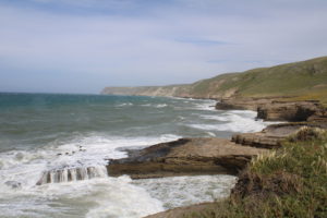
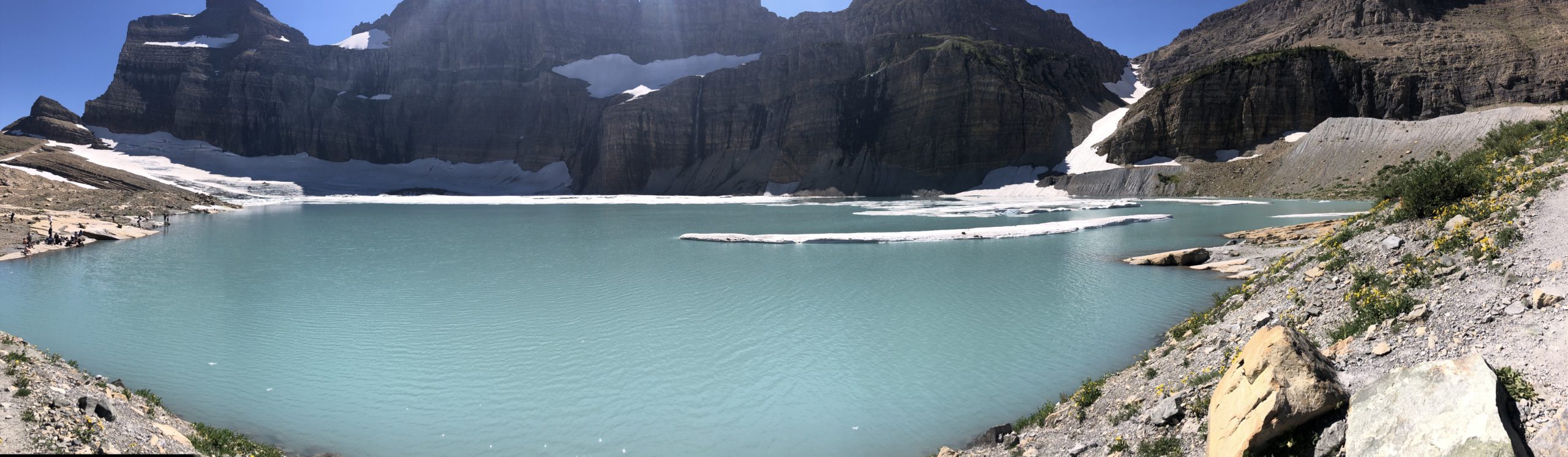
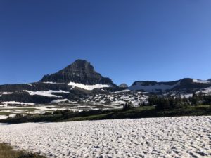
According to the National Park Service, at the end of the Little Ice Age in 1850, there were about 80 glaciers in Glacier National Park. Still, other sources quote that there were 150 when the park was founded in 1910. Whichever way you count it, in 2015, only 26 named glaciers met the criteria of .1 km squared. Between 1996 and 2015, aerial surveys show that every named glacier in the park shrunk, some by more than 80%, because when it gets hot … ice melts. Grinnell Glacier is one of the park’s most famous examples of glacier melt. Currently, Grinnell Glacier spills into Upper Grinnell Lake, which is compromised entirely of ice melt and did not exist at the time of the park’s founding in 1910. Repeat photography is a great way to see the impact of rising temperatures on glaciers in the park.


If the glaciers are disappearing… why do you call it Glacier National Park?

North Cascades National Park actually has the highest concentration of glaciers in the lower 48. Even Glacier National Park’s website name-drops a slew of other places to visit before talking about their glaciers in a blog titled “How to See a Glacier.” With many of Glacier’s glaciers expected to disappear within this generation, a common question is, “Why is Glacier National Park called Glacier National Park, and will it still be called that when the glaciers disappear?” The truth is, Glacier is partially called Glacier because of the ice that used to exist here. In fact, the Kootenai name for the Glacier region is Ya·qawiswitÌ“xuki, which translates to “the place where there is a lot of ice.” But the exciting answer is that Glacier will always be called Glacier because when we talk about the park’s name, we’re referring to two things: the glaciers in the park and the unique glacial geology that Glacier is most famous for.


Some examples of that Glacial geology include:
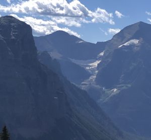
 

The Garden Wall seen from the Highline Trail

Arêtes

Arêtes are thin and jagged ridgelines formed by two glaciers carving on either side of the ridge. A famous example of this in Glacier is the Garden Wall which you can see from Lake McDonald, the Going-to-the-sun Road, the Highline trail, or the other side of the wall on the Grinnell Glacier Trail.
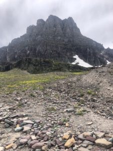
Mt. Reynolds at Logan Pass

Horns

Horns were formed when a mountain was scraped vertically by glaciers on three or more sides to create a thin horn-like shape. Some good examples are Little Matterhorn, which you can get a great view of from Snyder Lake, Mount Reynolds, which you can check out at Logan Pass, and Flinch Peak in Two Medicine.


Weasel Collar glacier has carved out a cirque it spills out of

Cirques & Tarns

A cirque is a bowl left behind where a glacier carved out rock in a scooping fashion. You can think of the glacier as an ice cream scooper and the cirque as the Ben and Jerry’s pint it’s putting a dent in. A tarn is the lake, ice, or debris filling a cirque.
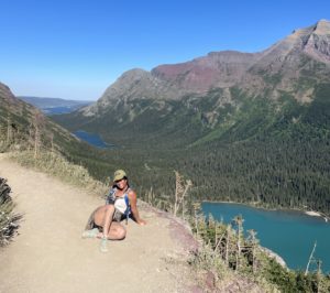
Behind this silly girl is a series of Paternoster Lakes flowing down from Grinnell Glacier

Paternoster Lakes

Paternoster Lakes are trails of lakes left behind as a glacier retreated down a valley and scooped out several depressions. Interestingly, they are called this because they resemble rosary beads strung together. Swiftcurrent Valley is a perfect example, with Bullhead Lake, Redrock Lake, and Fishercap Lake forming their own “string” of paternoster lakes.

The glaciers that formed the horns at Logan Pass left behind moraines on the Hidden Lake trail

Moraines

Moraines are piles of rock and debris left behind by glaciers. A terminal moraine is a dump left at the end of a glacier’s trail. Lateral moraines are the debris pushed to the side as a glacier carves its path. Bonus-fun-fact-not-related-to-Glacier: Long Island in New York is the terminal moraine left behind by the glaciers that carved out the Hudson River Valley.

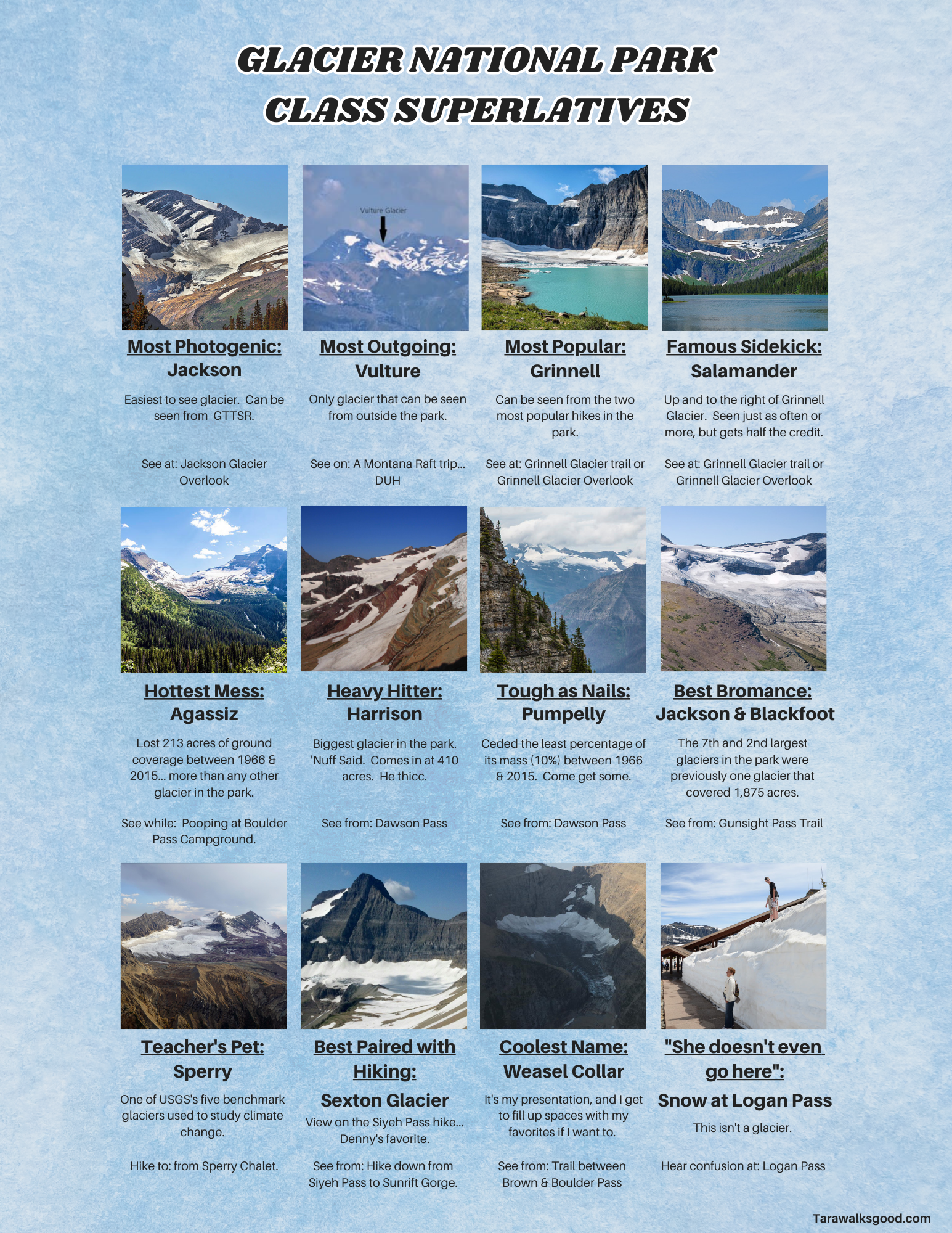
So that’s all well and cool, but let’s be honest: you want to know about the glaciers and where to see them. I get it. I’ve created a little cheat sheet for you here, reviewing some of the key named glaciers still left in the park, why they’re significant, and where you can see them. And I did them High School Class Superlative style because I thought it would be fun for me. And it was. Please enjoy!


Sources & Suggested Reading:

Overview of Glacier National Park’s Glaciers by Glacier National Park

How to See a Glacier by Glacier National Park

Mapping 50 years of Melting Ice in Glacier National Park by The New York Times

Status of Glacier’s in Glacier National Park by USGS

Welcome to Channel Islands National Park

Channel Islands National Park is a collection of five islands off the Southwestern coast of California: Santa Rosa, Santa Cruz, Anacapa, San Miguel, and Santa Barbara. Isolation from the continental United States has led to an extensive collection of endemic species found only on these islands, earning them the nickname “the Galapagos of the National Park System.”

The Channel Islands can only be reached by boat or airplane, meaning Channel Islands National Park is one of the lesser visited parks in the National Park System, coming in at 47 out of 63 parks in the visitation ranking for 2022*. It is their remoteness and the fact that you will be sharing an entire island with tens of additional people at most that make traveling to them feel like an extravagant adventure.

From the meadows and white-sand beaches of Santa Rosa to the volcanic cliffs and jagged peaks of Santa Cruz, the range of ecosystem diversity between the islands (not counting the marine ecosystem you experience traveling to the islands) makes Channel Islands National Park one of my new favorite parks. While they take a little more planning to get to, the Channel Islands cannot be missed! Plus… they’re the setting for everyone’s favorite elementary school read, Island of the Blue Dolphins. This is your moment if you have been waiting to let out your inner Karana. Go make an otter friend!

*Annual Park Ranking report


Location:

Off the Coast of Southern California.

Ferries to the islands are run by Island Packer Cruises, located in Ventura and Oxnard, California.

 
Visited:

April 2023

 
Go to:
  • Explore coastal and marine ecosystems via snorkeling, tidepool exploration, and kayaking.
  • Have foxes as dinner guests.
  • Let your inner Darwin out and study endemic species and wildlife.
  • Be alone and play Survivor.
 
When to go:

Winter or early spring for whale-watching.

Gray whales migrate through the Santa Barbara channel throughout the winter. Although transportation to the islands pauses during the colder months, you can still book a whale-watching tour with Island Packer Cruises in the off-season.

Spring for wildflowers.

The islands are known for their unique wildlife and endemic species, so if you want to unleash your inner Darwin, spring will be your moment to see flowers and trees in bloom that you can’t see anywhere else. Tree Sunflowers (lovingly nicknamed Dr. Suess trees) bloom in March and April and create a whimsical atmosphere.

Summer for snorkeling or scuba-diving.

One mile of water around each island is included in Channel Islands National Park, and six miles around each island mark the Channel Islands National Marine Sanctuary. The Sanctuary forms the largest network of marine protected areas off the continental United States coast. Snorkeling gear can be rented earlier in the season, but snorkeling tours officially start on July 1st. You’ll want to go when the water is slightly calmer and warmer, anyways! Book your kayaking and snorkeling tours through the Santa Barbara Adventure Company.

 
Flora & Fauna Seen:
  • Santa Rosa Island Fox
  • Santa Cruz Island Fox 
  • Allen’s hummingbird
  • California Sea Lion
  • Harbor Seal
  • Common Dolphin
  • Humpback Whale
  • Risso’s Dolphins
  • Elephant Seal
  • Soft-leaved Island Paintbrush
  • Sea Anemones
  • Bat stars
  • Sea Urchins
  • Torrey Pines
  • Abalone
 
Favorite Hikes:

On Santa Rosa: Lobo Canyon. 

9.0 miles round-trip from the pier (add 3.0 miles if you are hiking to and from the Water Canyon campground).

Tafoni in Lobo Canyon

This wildflower-filled canyon was shaped by wind and water into beautiful honeycomb shapes called tafoni. Follow the canyon down to the shore, where you’ll have stunning views of the northern coast of Santa Rosa Island.

Lobo Canyon on AllTrails. Note: This map picks up at the official trailhead into Lobo Canyon.  You’ll need to walk along Smith Highway from the pier for several miles to get there.

On Santa Cruz: Pelican Bay.

4.6 miles round trip hike from the Prisoners Harbor Pier.

This hike is on the portion of Santa Cruz owned by The Nature Conservancy. Hikers must get a permit and sign a waiver in advance, which can be obtained from Island Packer Cruises. With five canyon crossings, it’s a short but challenging hike, but it ends at a private bay littered with abalone shells and possibly even a seal companion. It’s well worth the trek!

Pelican Bay on AllTrails.

Channel Islands National Park Trail Map


Planning Tips:

#1 – Aim to book your ferry and campgrounds at least a few months in advance.

We booked our ferries and campgrounds in late January/early February for a trip in mid-April, which is still in the park’s off-season. Consider booking even farther out for summer trips when visitation numbers rise. 


#2 – Book day trips online.  Book island-to-island and overnight trips over the phone for max flexibility.

Day trips to the islands can be booked directly through the Island Packers website. If you want to stay overnight or be transported directly from one island to another, call and discuss your itinerary for your best options. We were asked to provide our campsite number when booking an overnight trip with Island Packers. Campsites can be booked on Recreation.gov. 


#3 – Pack your gear for the ferry appropriately.

You will not be allowed to bring any single item over 45 pounds on the ferry and no more than 60 pounds of gear total. Your luggage should not have any dangling items. Camping and backpacking gear are stored out of reach for the entire ferry ride, so make sure you load your day pack with your camera, snacks, and any gear you’ll want for the next few hours. Gas canisters and rechargeable batteries need to be placed into safety canisters before you board, so have them easily accessible to hand off to the crew! Read more about gear requirements for the ferry here.


#4 – Consider using a wagon to transport gear.

The campgrounds are a bit of a walk from the dropoff at the piers.  We used our backpacks to bring gear to our site. However, the Scorpion Canyon Campground and Water Canyon Campground are less than 2 miles from the piers and follow dirt roads. Many campers had wagons and carts they brought and wheeled their gear to and from the campsites instead.


#5 – Be prepared for the possibility that your trip could be longer than expected.

Be prepared for the time of your ferry to change, especially in the spring and fall. If wind and waves look like they’ll be building, the ferry may change its operation times for any given day or cancel trips altogether to avoid dangerous conditions. There are no resources to resupply food on the islands, and some campsites do not have water. 


#6 – Lock up your food and toiletries.

There are foxes at the campgrounds. They have become very accustomed to people. Yes, they are ridiculously adorable. But yes, they will steal your food. Use the provided fox boxes at each site and don’t feed the wildlife.


Helpful links for planning:
 
Other nearby attractions:

Santa Monica State Park

 
If you like this, you might also like:

For beaches, tidepools, and coastal rock formations:

  • Acadia National Park
 
Recommended pre-trip reading, listening, and viewing:

Island of the Blue Dolphins by Scott O’Dell.

Alie Ward’s Dolphinology episode on Ologies.

The Coastal Seas episode of Our Planet on Netflix.


Channel Islands National Park Itinerary


Day 1:

We started by taking the ferry to Santa Rosa Island. On our way, we saw Common Dolphins and California Sea Lions. After setting up camp at Water Canyon Campground, we hiked to Lobo Canyon and made some fox friends along the way.

Key Activities: Lobo Canyon Hike (see above).

Slept at: Water Canyon Campground

Day 2:
Morning Walk at Water Canyon Beach

After a leisurely morning at camp, we walked along Water Canyon Beach to enjoy the coast. We thought we could walk to Skunk Point along the beach and create a loop back on the Coastal Road. This turned out not to be possible as we got cliffed out and had to turn back. After retracing our steps, we followed the Coastal Road to the Skunk Point turnoff, adding the Torrey Pines Trail along the way. We found terrific tide-pooling at Southeast Anchorage.

Key Activities:

• Water Canyon Beach
• Torrey Pines Trail
• Skunk Point
• Tidepooling

Slept at: Water Canyon Campground

Day 3:
Lupine, California Poppies, Tree Sunflowers, and Paintbrush were aplenty on the Cherry Canyon Trail.

We wrapped up our time on Santa Rosa Island by hiking up Black Mountain to view the East Coast, Santa Cruz Island, and even a bit of San Miguel before returning to the pier via the Cherry Canyon Trail which offered astonishing wildflower viewing. There was time for some final tide-pool exploration down on the beach before taking the ferry back to Ventura, where we glimpsed Risso’s dolphins and Humpbacks on the ride back.

Key Activities:

  • Black Mountain
  • Cherry Canyon Trail

Slept at: Point Mugu State Park

Day 4:

After three intense days of hiking, we took a rest day on the mainland. We checked out the Channel Islands National Park Headquarters and arrived just in time to crash a ten-year-old’s birthday and join a tidepool talk.

Key Activities: Channel Islands National Park Headquarters

Slept at: Foster Red Mountain Park (This was the closest camping we could find to the Ventura ferry. You need to get to the ferry early, so we recommend staying as close as possible).

Day 5:

Back to the Islands! We took the boat to Scorpion Anchorage on Santa Cruz Island. Each island has a 60-70 page interpretive guide including self-guided interpretive hikes. You can snag a guide for free at any of the piers or campgrounds. We hiked to Potato Harbor, Cavern Point, and Scorpion Rock Overlook, following the trail guide for Cavern Point.

Key Activities:

  • Cavern Point
  • Potato Harbor
  • Scorpion Rock Overlook

Slept at: Scorpion Canyon Campground

Day 6:

Time to explore the water. We booked a kayak tour with Santa Barbara Adventure Company. I about blacked out with glee when we saw a harbor seal up close and personal lounging on a rock. We also got to kayak through sea caves! Post kayak adventure, we hiked to Smugglers Cove to explore the other side of the island, arriving just in time to see brown pelicans having a feeding frenzy at dusk.

Key Activities:

Slept at: Scorpion Canyon campground

Day 7:

Finally… time to backpack. We loaded up on water (there is no water at the Del Norte Campground and no reliable water source on the trails) and headed up the Montañon Trail over Montañon Ridge. From here, we picked up the Del Norte trail to the Del Norte Backcountry campground for a ~9-mile hike total with some elevation gain to get over that ridge.

Key Activities: Backpack along the Montañon Ridge to Del Norte Campground

Slept at: Del Norte Backcountry Campground

Day 8:

For our last day, we finished our backpacking by heading down to Prisoner’s Harbor pier. We locked up our bags for the day at the pier in the provided fox boxes and hiked the Pelican Bay trail before taking the ferry back to the mainland.

Key Activities: Pelican Bay

Slept at: Foster Red Mountain Campground

See more pictures from my Channel Islands trip on Shutterstock here.